


Mallorca by motorcycle
Mallorca by motorcycle: 4 definitive routes (and how to enjoy them safely)
Mallorca fits entirely in the tank of a motorcycle… but not in a single day. The island is a playground of curves with the sea on one side and the Serra de Tramuntana mountains on the other, a World Heritage Site thanks to its cultural landscape of dry stone walls, canals, and terraces that have climbed the mountainside for centuries. On a motorcycle, this blend of culture and geography can be experienced through hairpin turns, viewpoints, and cafés in stone villages.
Before you go: when to go, rules, and logistics
Best time of year. Spring (March–June) and fall (September–November) are golden: less traffic, mild temperatures, and clear visibility. In the height of summer, the heat and the coaches demand more patience, especially in Tramuntana and Formentor.
Speeds and lights. In Spain, the general speed limit for motorcycles is 120 km/h on highways/motorways and 90 km/h on conventional roads, although the road owner may set a limit of 100 km/h if there is a physical separation. In cities, lower limits apply (be careful with 30 zones). Always carry lights in tunnels and in low visibility.
Access to Formentor (2025). From June 1 to October 30/31, access is restricted from 10:00 a.m. to 10:00 p.m. You can enter Formentor Beach (PK 8) without permission only if the parking lot is not full; access to the lighthouse is by permission only (alternative: TIB bus 334). Cameras penalize you if you enter during restricted hours. Plan for sunrise/sunset and respect barriers and panels.
Equipo y conducción. Always wear a helmet (mandatory) and ventilated gear with protective padding. In Tramuntana there are damp shadows and goats: take wide turns, look far ahead, and brake in a straight line. In summer, stay hydrated and avoid the middle of the day.
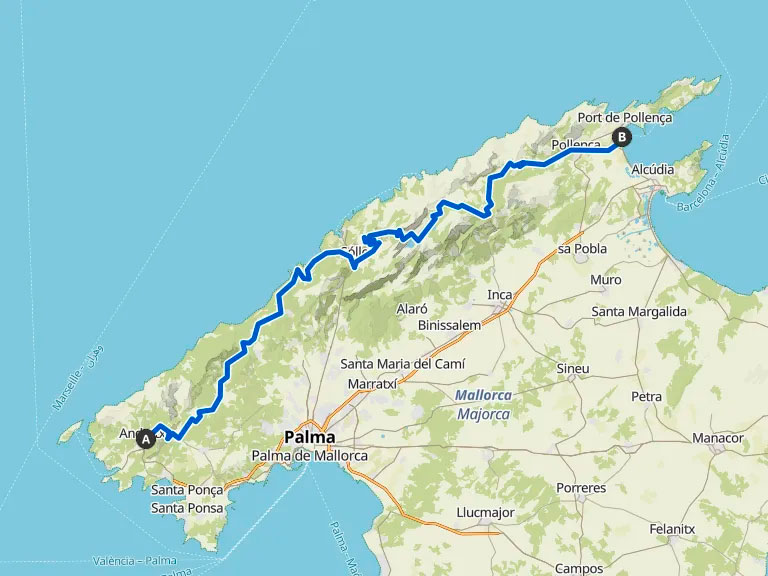
The backbone: Ma-10 from Andratx to Pollença
Summary. The Ma-10 highway runs from west to north through the Tramuntana Mountains for just over 100 km. It’s not the fastest highway: it’s a thread of asphalt that connects viewpoints, monasteries, and hanging coves. If you do it “right,” your day will fly by between stops.
Suggested itinerary (full day):
Andratx → Estellencs (photo stop at the cliff) → Banyalbufar (café with views) → Valldemossa (walk through two curves) → Deià (Sa Foradada viewpoint) → Sóller (orange and pine scent tunnel) → Optional detour to Sa Calobra (see Route 2) → Cúber and Gorg reservoirs Blau → Lluc (sanctuary and shadow) → Pollença.
Why it’s cool. It varies constantly: cliffs, olive groves, short tunnels, cold valleys, and Atlantic light on the Mediterranean. It’s the best “picture” of Mallorca on two wheels. And it’s framed by a UNESCO landscape that you’ll see: the dry stone walls that terrace the hillsides are not decoration, they are living history.
Tips: Get up early to avoid encountering coaches on the Valldemossa–Deià–Sóller routes. If you’re going in a group, rotate the “open-close” so everyone can enjoy the viewpoints without rushing.
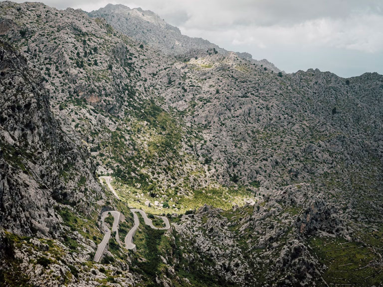
The engineering marvel: Sa Calobra (Ma-2141) and the “Nus de sa Corbata”
Summary. From the MA-10, a small road winds down 9–13 km between limestone walls and ends at sea level in Sa Calobra. It was designed by Mallorcan engineer Antonio Parietti, who in the 1930s drew that 270° curve known as the “tie knot” to lose height without tunnels. Today is a cycling ritual and a biker pilgrimage.
How to fit it in. Base yourself in Sóller or Lluc and start early: first thing in the morning you can enjoy the descent almost alone and climb back up without the heat. Avoid coach traffic peaks.
What to expect. Intertwined hairpin turns, good road surface with a few loose stones, changing light, and views that make you want to stop at every bend. In the background, the Pareis stream and the deep blue sea.
Driving. Be patient when overtaking bikes and buses: the road is narrow. Always leave room for the unexpected (tourists who look more at the horizon than in their mirrors).
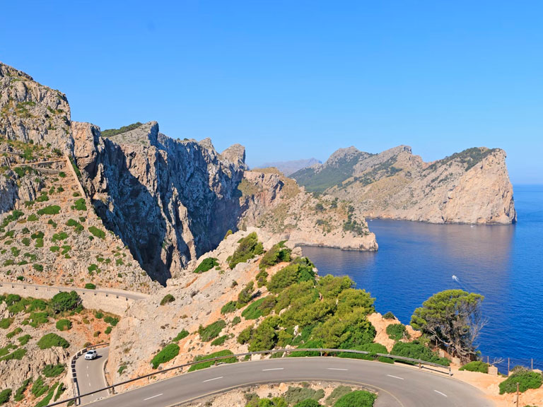
Cap de Formentor: lighthouse, cliffs, and clear rules
Summary. The Ma-2210 is a footbridge suspended between turquoise bays and limestone rock. From Pollença and Port de Pollença, climb up to the Mirador des Colomer viewpoint, continue through pine forests and coves (Figuera, Murta) and finish at the lighthouse.
Regulation 2025 (read it carefully).
Formentor Beach (PK 8): unauthorized access only if there are free spaces (green light + barrier raised + sign indicating open).
Faro (PK 8.7): authorized vehicles only from 10:00 a.m. to 10:00 p.m. (barrier and cameras). Alternative: TIB bus 334 with stops at viewpoints.
If you enter before 10:00, you must leave the restricted area before 10:00 or be beyond PK 8.6 at 09:58 to avoid penalties.
Plan for sunrise or sunset and check the dynamic signage.
Idea de media jornada. Port de Pollença → Mirador des Colomer (stop) → Formentor Beach → (bus to the lighthouse if applicable) → return via the Ma-2200, with a swim and a sandwich.
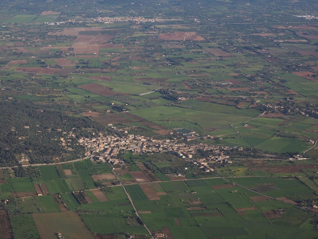
Route 1 – Panoramic Es Pla: windmills, chapels, and wine (½–1 day)
Palma → Algaida → Randa (Santuari de Cura) → Montuïri → Sineu → Petra (Bonany) → Porreres → Llucmajor → Palma
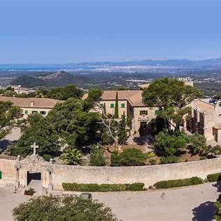
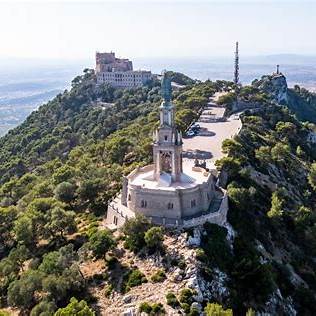
Why it’s cool. This is Mallorca at its most peaceful: fields, windmills, and solitary hills with 360° views. The climb up Puig de Randa (543 m) via the Ma-5018 offers you a balcony overlooking the entire island and a cloister where you can relax (coffee recommended).
Key stops
Santuari de Cura (Randa). Viewpoints, museum, and the feeling of having Mallorca at your feet. Access via the MA-5018 (narrow, clean road, ideal for motorcycles).
Montuïri. Land of windmills: if you like photos with windmill blades, take a short detour to see them up close.
Sineu. If it’s Wednesday, its market is one of the largest on the island (from 8:00 a.m. to 1:00 p.m.), with an authentic rural atmosphere.
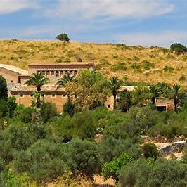
Petra – Bonany Sanctuary. Another hill with views (Puig de Bonany, 317 m); winding road and peaceful chapel. In the village, Casa Museu de Juníper Serra for a touch of history.
Driving tips
Es Pla is windy: watch out for crosswinds on open straights.
Country roads with good surfaces and some shady stretches under pine trees as you approach the chapels.
If you are going to taste wines in the Binissalem DO, have someone else drive you home afterwards or leave the visit until the end of the day.
Route 2 — Northern Levante: Artà, Betlem, Capdepera, and the Mesquida dunes (½–1 day)
Artà → Betlem Chapel → Colònia de Sant Pere → Capdepera → Cala Mesquida
Why it’s cool. Narrow roads winding through holm oaks and limestone, views of Alcúdia Bay, a medieval fortress, and a protected dune system where the wind combs the sand.
Sections and stops
Artà → Ermita de Betlem (Ma-3333). A winding asphalt road leads to a chapel nestled between mountains; a photo stop is a must at the end of the cypress grove. The chapel is located at an altitude of about 280 m and was founded in 1805.
Colònia de Sant Pere. A peaceful seaside promenade for stretching your legs.
Capdepera (castle and lighthouse). The Castell de Capdepera crowns the village with views of the Menorca Channel; to the east, the Capdepera Lighthouse (1861) watches over the cliff.
Cala Mesquida. Living dunes, pine forest, and open sea. Mesquida, Moltó, and Agulla have been declared ANEI (Natural Area of Special Interest): please respect the walkways and do not walk on the dunes.
Nature extras
If you like combining motorcycling with short trails, head to the Parc Natural de la Península de Llevant (center in s’Alqueria Vella) for gentle rides to Cap Ferrutx and wild viewpoints.
Driving tips
The Ma-3333 to Betlem is narrow, with steeper slopes in the last few kilometers; drive carefully and leave plenty of room in hairpin turns.
In Mesquida, the wind usually blows from the north: park with the front wheel firmly planted and leave the motorcycle slightly against the wind.
Route 3 — Southern Levant: Felanitx, Sant Salvador, Portocolom, and Mondragó (½–1 day)
Felanitx → Santuari de Sant Salvador → Portocolom → Santanyí → Parc Natural de Mondragó → (Cala Figuera optional)
Why it’s cool. It combines a short mountain pass with turquoise coves and small beaches within a natural park.
Sections and stops
Felanitx → Santuari de Sant Salvador. Classic climb via the Ma-4011 (turn off from the Ma-4010): 5 km of curves to the monastery and the large cross on Picot at the summit (509 m). An entertaining road, good pavement, and endless views.
Portocolom. Old port, pause in front of the lighthouse and the pier.
Mondragó Natural Park. Park in the designated area and walk a few minutes to s’Amarador or Cala Mondragó; white coves, pine forests, and protected wetlands (≈766–785 ha of parkland).
Cala Figuera (optional). Mini-fjord with small boats, ideal for having a snack before heading back.
Driving tips
In Sant Salvador, some curves are blind: brake straight ahead, look far ahead, and avoid crossing the line.
There are pedestrians and bicycles on the access roads to Mondragó: drive slowly and park outside the dune area.
Practical tips that make a difference
- Manage your day by hours, not by miles or Km. In Tramuntana, 120 km with photo stops and a few coves will take up your entire day (and what a pleasure it is).
- Formentor requires planning. Check schedules/restrictions and decide whether to watch the sunrise at the lighthouse (leaving early) or combine a motorcycle with the TIB 334 bus. They issue fines using cameras.
- Respect limits and signage. 120 on highways; 90–100 on conventional roads depending on the section; lights in tunnels. The fun is in the curves, not on the straights.
- Hydration and shade. In July/August, schedule stops every 45–60 minutes. Bring extra water and a damp buff for your neck.
- Get up early (or take a nap). 8:00–10:30 a.m. and 6:30–8:30 p.m. are VIP slots for filming without heat or buses.
- Park carefully. In villages in the Tramuntana mountains, there are blue zones and tight spaces; look for a level spot and leave enough room to turn the handlebars without touching anything.
- Weather Plan B. If the Tramuntana wind dawned with low clouds, head east (Llevant) or south (Cura/Sant Salvador). The microclimate rules.
- Fuel. Full in Palma, Inca, Sóller, or Pollença. In between, there are fewer options than you might think; don’t wait until the weekend to make your reservation.
- Total respect for cyclists. Mallorca is a mecca for cyclists: generous distances between vehicles and patient overtaking (with smiles).